What is northern mexico known for?
The northern part of Mexico is one of the least populated region in the country. It has a distinctive character.
Northern Mexico: a region apart
Northern Mexico stretches across vast expanses of desert, mountain ranges, and isolated valleys that feel removed from the rest of the country. This sparsely populated territory maintains a distinct character shaped by geography and distance, where small towns emerge from endless horizons and the landscape commands respect through its scale and severity.
The region’s isolation has fostered a unique cultural identity, blending indigenous traditions with frontier pragmatism. Here, ranching communities have adapted to harsh conditions for generations, developing their own customs, music, and ways of life that reflect the demands of desert living.
Canyon country
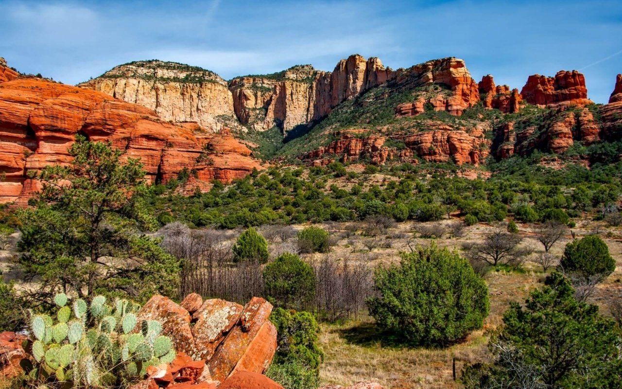
The Sierra Madre Occidental cuts through northern Mexico, creating some of North America’s most dramatic canyon systems. These gorges carve through ancient volcanic rock, forming precipitous walls that drop hundreds of meters into river valleys below. The landscape rivals Arizona’s Grand Canyon in scope and geological complexity, yet remains largely unknown to international travelers.
Indigenous Rarámuri people have inhabited these canyons for centuries, building settlements on remote ledges and maintaining traditional ways of life despite the challenging terrain. Their knowledge of the landscape and survival skills in this harsh environment represent one of Mexico’s most remarkable cultural adaptations.
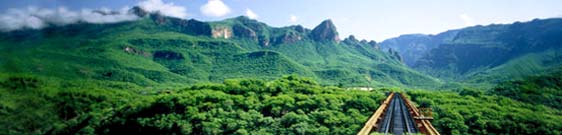
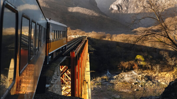
The Chihuahua – Los Mochis railway
This engineering marvel winds through the Sierra Madre Occidental, connecting the desert city of Chihuahua with the Pacific coast port of Los Mochis across 653 kilometers of mountainous terrain. The railway crosses 37 bridges and passes through 86 tunnels, climbing from sea level to over 2,400 meters elevation while navigating canyon walls and mountain passes.
Built over decades and completed in 1961, the line serves both practical transportation needs and offers one of Mexico’s most spectacular train journeys. The route provides access to remote mountain communities and reveals landscapes that remain largely unchanged since indigenous peoples first settled these highlands centuries ago.

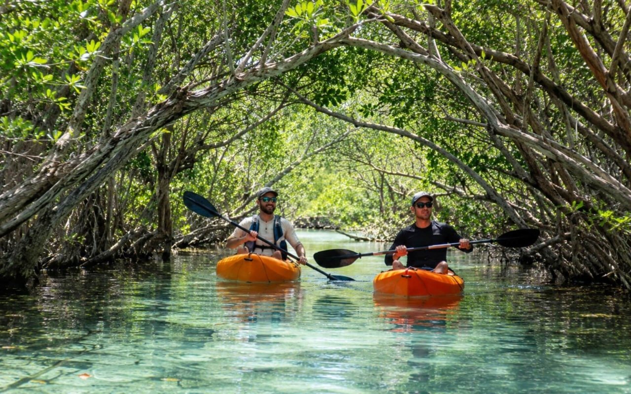
Coastal destinations of Mexico
Mazatlán anchors the Western Pacific coast of Mexico as Sinaloa’s primary beach destination, drawing visitors for its consistent surf breaks, deep-sea fishing grounds, and February carnival celebration. The city’s malecón stretches along the waterfront, connecting the historic center with the hotel zone, while sportfishing boats target marlin, sailfish, and dorado in offshore waters.
Beyond major resorts, smaller coastal towns offer different experiences. Sayulita maintains its character as a surfing village despite growing popularity, with consistent beach breaks and a walkable town center filled with local restaurants and artisan shops. On the Gulf of California, Bahía Kino provides access to calm waters and desert landscapes where the Sonoran Desert meets the sea.
Northern and eastern frontier territory
The states of Coahuila, Nuevo León, Tamaulipas, and Durango contain some of Mexico’s most challenging and least-visited terrain. These border regions feature rugged mountain ranges, hidden canyon systems, and vast stretches of Chihuahuan Desert that attract adventurers seeking experiences beyond conventional tourism.
The Sierra Madre Oriental creates dramatic topography where limestone formations have eroded into complex cave systems and vertical-walled canyons. Rock climbers find multi-pitch routes on solid limestone walls, while cavers explore underground networks that extend for kilometers beneath the surface. The region’s isolation means that many canyons and peaks remain unnamed and rarely visited, offering genuine exploration opportunities for experienced outdoor enthusiasts.
Desert springs create oases where waterfalls drop into clear pools, providing rappelling and canyoneering opportunities in settings that combine technical challenge with striking desert scenery.


Desert phenomena and geology: Zona del Silencio and El Pinacate
Zona del Silencio
The Zona del Silencio in Durango attracts researchers and astronomy enthusiasts due to its unusual concentration of meteorite impacts and reported electromagnetic anomalies. This remote desert region, where radio signals allegedly weaken or disappear entirely, has become a destination for those seeking both scientific curiosity and desert solitude under exceptionally dark night skies.
Chihuahuan and Sonoran deserts
The Chihuahuan and Sonoran deserts showcase distinct geological formations created by different volcanic and erosional processes. El Pinacate National Park preserves a volcanic landscape of cinder cones, lava tubes, and craters that NASA has used for astronaut training due to its resemblance to lunar terrain. The park’s indigenous name, “place where the mountain fell apart,” reflects the dramatic volcanic activity that shaped this UNESCO World Heritage site.
El Potrero Chico and Piaxtla Canyon, adventure destinations
El Potrero Chico
Near Monterrey, El Potrero Chico offers limestone cliffs that rise 800 meters from the desert floor, creating one of Mexico’s premier big-wall climbing destinations. The area’s reliable weather and variety of routes, from beginner-friendly sport climbs to demanding multi-day ascents, have established it as a winter training ground for international climbers.
Piaxtla Canyon
Durango’s Piaxtla Canyon combines technical rock climbing with water features, where rappelling routes descend alongside waterfalls that drop 30-35 meters into swimming holes carved from granite bedrock. The canyon’s year-round water flow creates a microclimate that supports vegetation unusual for this elevation and latitude.
Tropical enclaves: El Cielo and Sierra Huasteca
El Cielo Biosphere Reserve
El Cielo Biosphere Reserve in Tamaulipas protects 144,530 hectares of cloud forest and tropical vegetation that exists as an ecological island within the surrounding desert landscape. This elevation-dependent ecosystem supports species more commonly found in Central America, including jaguarundi, ocelots, and over 200 bird species.
Sierra Huasteca
The broader Sierra Huasteca region maintains strong indigenous traditions, particularly in music and crafts, where Huastec and Nahuatl communities preserve pre-Columbian instruments and ceremonial practices alongside colonial-era influences.
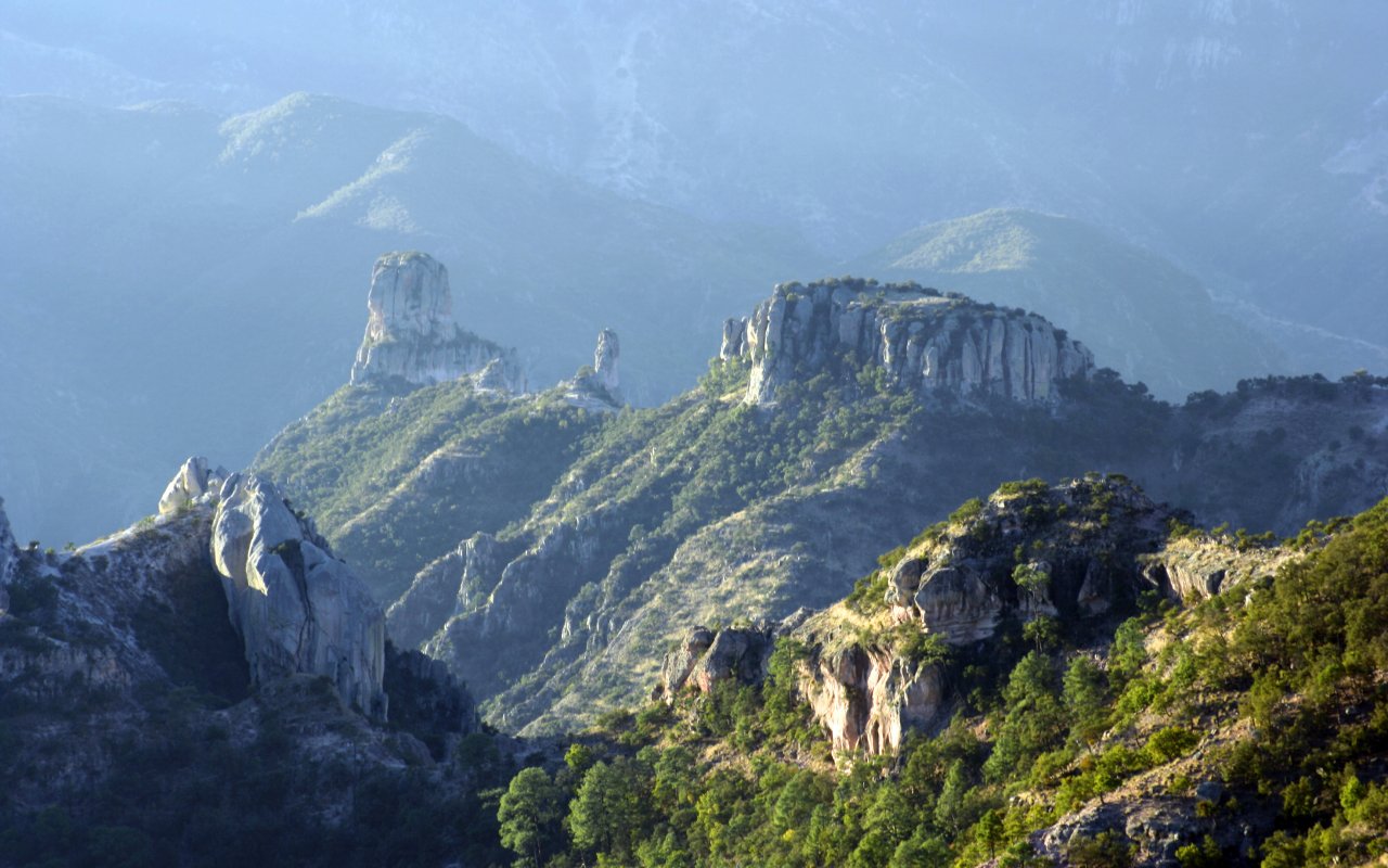
Sierra Tarahumara and Copper Canyon: indigenous homeland and extreme landscapes
The canyon network
The Barranca del Cobre encompasses a network of twenty interconnected canyons that cut through the Sierra Madre Occidental, creating gorges deeper and wider than Arizona’s Grand Canyon. These canyons reach depths of 1,800 meters while peaks soar to nearly 3,000 meters elevation, forming one of North America’s most dramatic mountain landscapes.
The Rarámuri people
The Rarámuri people, often called Tarahumara by outsiders, have inhabited these remote canyons for over 400 years, developing extraordinary endurance running abilities that have earned them the nickname “running people.” Their traditional ultramarathon races cover distances exceeding 160 kilometers through canyon terrain, inspiring modern ultra-running events including the annual Ultramaratón de los Cañones, a challenging 100-kilometer race that attracts international athletes.
Adventure opportunities beyond running
Mountain activities
The canyon system attracts mountain bikers, rock climbers, and hikers seeking technical challenges in pristine wilderness settings. Trails range from day hikes to multi-day expeditions that descend into tropical canyon floors where fig trees and palm species grow alongside desert plants found on the rim.
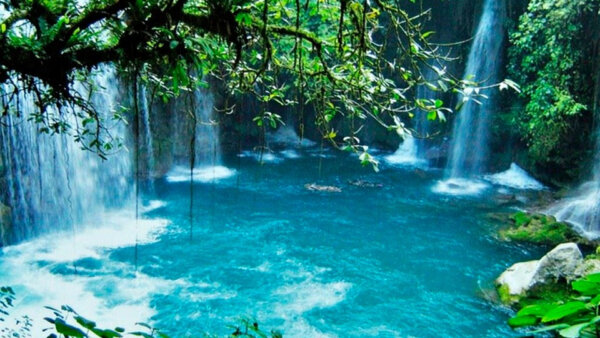
Basaseachic Falls
Basaseachic Falls drops 246 meters in a single cascade, ranking among the world’s highest waterfalls. The falls flow year-round, fed by snowmelt and seasonal rains that create varying water volumes throughout the year. Access requires a moderate hike through pine-oak forest that provides habitat for black bears, mountain lions, and over 200 bird species.
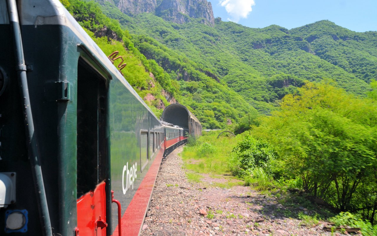
Chepe railway: engineering through impossible terrain
Construction challenges
The Ferrocarril Chihuahua al Pacífico, known as “El Chepe,” required six decades to complete due to the challenging mountain topography. Construction began in 1898 and finished in 1961, creating a 653-kilometer route that connects the Pacific port of Los Mochis with the desert city of Chihuahua.
The journey experience
The railway climbs 2,400 meters in elevation while crossing 37 bridges and passing through 86 tunnels carved through solid rock. The journey reveals landscapes that change from tropical coastal plains to pine forests and finally high desert, passing through Rarámuri communities that remain largely isolated from modern Mexico.
Key stops along the route
Passengers can disembark at stations like Divisadero, perched on canyon rims with views extending 50 kilometers across layered rock formations, or Creel, a logging town that serves as a base for canyon exploration and cultural encounters with Rarámuri artisans and runners.
The Sonoran desert: iconic borderland wilderness
Landscape of legend
The Sonoran Desert stretches across northwestern Mexico and southwestern United States, covering 260,000 square kilometers of the most biologically diverse desert in North America. This landscape of towering saguaro cacti, rocky mountains, and vast bajadas creates the archetypal image of the American Southwest immortalized in countless Western films.
Desert ecology of nortern Mexico
Unlike other North American deserts, the Sonoran receives rainfall during both winter and summer seasons, supporting remarkable plant diversity including over 2,000 species. Saguaro cacti dominate the landscape, growing up to 18 meters tall and living for 150-200 years. These giants provide nesting sites for Gila woodpeckers and elf owls, while their flowers and fruit support bats, birds, and desert animals.
Wildlife adaptations
Turkey vultures soar on thermal currents above desert floors where javelinas, coyotes, and desert bighorn sheep navigate between organ pipe cacti and ocotillo plants. The desert’s extreme temperatures—ranging from below freezing in winter to over 50°C in summer—have shaped unique evolutionary adaptations among both plants and animals that allow life to flourish in this harsh environment.
Cultural significance
Beyond its role in popular culture, the Sonoran Desert has supported human habitation for thousands of years. The Tohono O’odham and Seri peoples developed sophisticated knowledge of desert resources, harvesting saguaro fruit, collecting medicinal plants, and navigating seasonal water sources that remain hidden to casual observers but sustain complex desert ecosystems.
Northern Mexican states
The states of Northern Mexico
Visit the state of Chihuahua in northern Mexico
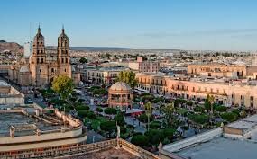
The state of Chihuahua is located in northern Mexico, in the northwest of the republic, occupying the largest territory in the country.
Thanks to its history, its indigenous and European roots, this warm-climate entity will enable you to discover all aspects of the state’s culture, visiting its villages, towns and natural wonders. In the city of Chihuahua, its capital, you can stroll through the streets and elegant plazas built during the colonial era and part of the 19th century, thanks to the important mining industry that flourished in this region.
In the city of Ciudad Juárez, you can visit the museums and leisure centers that make this destination so sought-after.
In the state of Chihuahua, you can also explore interesting archaeological zones, such as Paquimé, a mysterious pre-Hispanic city built of adobe.
In the surrounding area, you can pass through incredible natural landscapes, such as the Samalayuca dunes, ideal for mountain biking; the Basaseachi waterfall, much visited by abseiling and climbing enthusiasts; and the famous Copper Canyon, one of the world’s largest canyon systems.
You can also observe birds, mammals and a wide variety of flora. Here you can visit the state’s largest community and sample their delicious cheeses.
Along the way, you’ll also be able to pick up some of the region’s typical handicrafts, made by the Tarahumara and Rarámuri peoples.
Visit the state of Coahuila in northern Mexico : desert landscapes and cultural heritage
Natural wonders and outdoor activities
Coahuila encompasses Mexico’s third-largest state territory, stretching across diverse landscapes from mountain ranges to desert basins. The Sierra de Arteaga offers cooler mountain climate and pine forests ideal for hiking, rock climbing, and camping, providing relief from the desert heat that characterizes much of the state.
Cuatrociénegas presents one of Mexico’s most unique ecosystems, where over 200 spring-fed pools create oases in the Chihuahuan Desert. These crystal-clear pools, some reaching depths of 15 meters, support endemic species found nowhere else on Earth, including stromatolites—living rock formations created by ancient bacteria that offer insights into early life on the planet.
The Maderas del Carmen National Park protects critical habitat along the Texas border, serving as a corridor for black bears, mountain lions, and other wildlife that move between Mexico and the United States.
Paleontological treasures
Rincón Colorado and General Cepeda contain some of Mexico’s most significant dinosaur fossil sites, where Cretaceous-era sediments have preserved remains of hadrosaurs, tyrannosaurs, and other species that lived 70 million years ago. These discoveries have contributed important knowledge about dinosaur evolution and extinction patterns in North America.
Historic towns and wine country
Parras de la Fuente, designated as a Pueblo Mágico, claims to be the oldest wine-producing region in the Americas, with viticulture dating to 1597. The town’s colonial architecture and desert vineyards create an unexpected landscape where European winemaking traditions adapted to Mexican terroir.
Saltillo: Athens of the North
The state capital earned its nickname through its role as an educational and cultural center during the colonial period. Saltillo’s historic center features baroque churches and neoclassical buildings that reflect its importance as a trading hub between Mexico City and the northern frontier.
The city’s textile tradition produces saltillo sarapes, woven cotton blankets with distinctive geometric patterns that have become symbols of Mexican craftsmanship. These textiles require months to complete using traditional techniques passed down through generations.
Torreón: industrial heritage and monuments
Located in the Laguna region, Torreón developed as a railroad and cotton center in the early 20th century. The city’s architecture reflects this prosperity period, including the modernist Carmen Cathedral and the neoclassical Casino de la Laguna, now a cultural center.
The Cristo de las Noas monument stands 21.80 meters tall on Cerro de las Noas, offering panoramic views across the Laguna Comarca. The surrounding area features sand dunes at Bilbao, where desert landscapes create recreational opportunities for sandboarding and off-road exploration.
Durango in northern Mexico : desert film sets and mountain adventures
Climate and natural reserves
Durango experiences a semi-arid climate with distinct wet and dry seasons, receiving most of its annual precipitation during summer monsoons that transform desert landscapes into temporary green valleys. The state protects critical ecosystems through reserves like La Michilía, which preserves temperate forests at elevations above 2,000 meters, and the Mapimí Biosphere Reserve, part of the larger Chihuahuan Desert ecosystem that supports desert bighorn sheep, golden eagles, and over 350 plant species.
Adventure destinations and natural attractions
The Sierra Madre Occidental creates dramatic topography perfect for outdoor activities. Espinazo del Diablo (Devil’s Backbone) offers challenging rock climbing routes on volcanic formations, while the Rosario forest provides cooler mountain environments for hiking and camping among pine and oak trees.
Saltito waterfall cascades 20 meters into a natural pool surrounded by desert vegetation, creating an oasis where visitors can camp and observe the contrast between arid surroundings and lush riparian growth. Guadalupe Victoria reservoir supports recreational fishing in a wooded canyon setting, where bass and catfish thrive in waters surrounded by desert mountains.
Durango city: colonial architecture and cultural celebrations
The state capital showcases baroque and neoclassical architecture through landmarks like the cathedral with its twin towers, the Santa Ana temple, and colonial-era mansions that reflect the city’s wealth from silver mining and trade. The Casa del Conde de Suchil represents one of Mexico’s finest examples of 18th-century residential architecture.
The annual Feria Nacional celebrates the city’s founding with traditional dances including Matachines, where performers wearing elaborate headdresses and mirrors recreate indigenous and Spanish colonial fusion ceremonies. Regional polka music reflects the area’s German immigrant influence, while mariachi and banda music represent broader Mexican traditions.
Indigenous crafts and film heritage
Local markets offer Tepehuano textiles, ceramics, and fiber work that preserve pre-Columbian techniques adapted to available desert and mountain materials. These crafts represent one of Mexico’s smaller indigenous communities, whose traditional knowledge includes sustainable harvesting of desert plants for basketry and medicine.
The nearby village of Chupaderos served as a filming location for numerous Hollywood westerns during the 1960s and 1970s, when its authentic frontier architecture and desert surroundings provided cost-effective alternatives to American locations. The village maintains its film-set appearance, offering visitors glimpses into both actual frontier history and its romanticized Hollywood interpretation.
Nuevo Leon : industrial powerhouse and mountain adventures
Economic development and character
Nuevo León ranks among Mexico’s most industrialized and economically advanced states, built on a foundation of steel production, manufacturing, and international commerce. This economic success has created a distinctive regional identity that blends entrepreneurial spirit with northern Mexican traditions, making it one of the country’s most prosperous and modernized regions.
Underground wonders and cave systems
The state’s limestone geology creates extensive cave networks perfect for speleological exploration. Bustamante Caves extend over 2 kilometers underground, featuring massive chambers decorated with stalactites and stalagmites formed over millions of years. García Caves offer more accessible routes for beginners, with well-lit passages that reveal underground rivers and cathedral-like spaces carved by water through geological time.
Mountain parks and hiking destinations
Cumbres de Monterrey National Park encompasses 177,395 hectares of the Sierra Madre Oriental, protecting pine-oak forests and providing habitat for black bears, mountain lions, and over 200 bird species. The park’s most recognizable landmark, Cerro de la Silla (Saddle Mountain), rises 1,820 meters above Monterrey, creating the city’s iconic backdrop with its distinctive saddle-shaped profile.
Chipinque Ecological Park offers easily accessible mountain recreation just 30 minutes from Monterrey’s urban center, with hiking trails that range from family-friendly walks to challenging climbs reaching elevations above 2,200 meters.
Canyoneering and water features
Santa Catarina Canyon, known locally as Huasteca de Monterrey, provides dramatic limestone walls and desert vegetation perfect for rock climbing, rappelling, and photography. The canyon’s year-round accessibility and variety of routes attract both beginners and experienced climbers.
Matacanes Canyon combines hiking, swimming, and technical canyoneering through a water-carved gorge that requires rappelling down waterfalls and swimming through narrow pools. This challenging route has become one of northern Mexico’s premier adventure destinations.
Cola de Caballo National Park features a 25-meter waterfall that flows year-round, fed by mountain springs that create a microclimate supporting vegetation uncommon in the surrounding desert landscape.
Monterrey: industrial capital and cultural center
Mexico’s third-largest metropolitan area combines colonial architecture with contemporary design, creating a skyline that reflects both historical heritage and modern prosperity. The Palacio del Obispado (Bishop’s Palace) represents 18th-century baroque architecture, while the Museo de Arte Contemporáneo showcases one of Latin America’s most important modern art collections.
The city’s commercial success supports extensive shopping infrastructure and a culinary scene built around regional specialties. Cabrito (roasted young goat) represents Nuevo León’s signature dish, prepared using traditional methods that reflect the state’s ranching heritage. Local confections include glorias, milk-based candies that originated in nearby Linares and have become synonymous with regional cuisine.

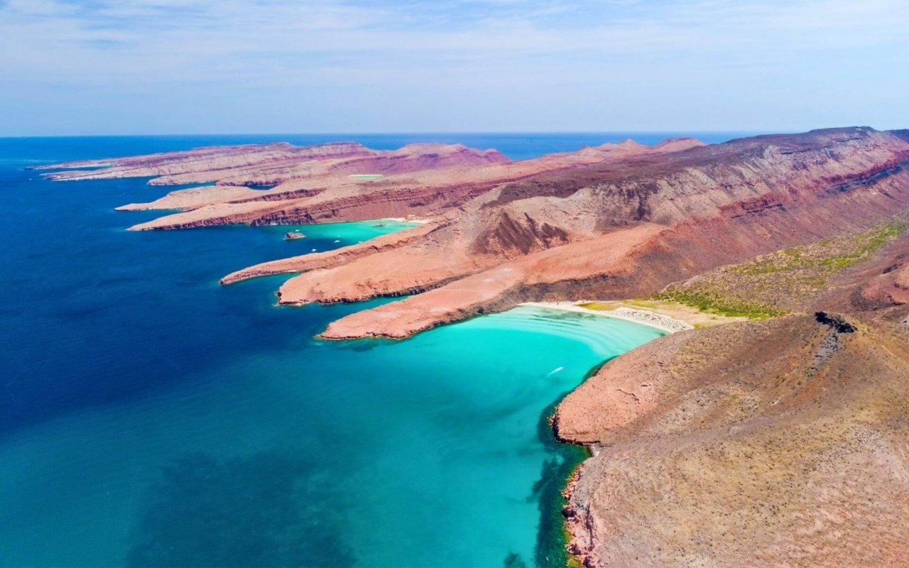
Sonora : where desert meets se
Coastal geography and commerce
Sonora’s 912-kilometer coastline along the Sea of Cortés creates diverse marine environments from protected bays to open ocean waters. This extensive shoreline supports both commercial fishing fleets and recreational tourism, with the deep-water port of Guaymas serving as one of Mexico’s primary Pacific shipping terminals for agricultural exports from the fertile valleys of central Sonora.
Guaymas combines industrial port facilities with tourism infrastructure including marinas designed for both commercial fishing boats and recreational yachts, plus resort developments that take advantage of the region’s desert climate and protected waters.
San Carlos and Tetakawi Hill
San Carlos Bay centers around one of Mexico’s largest recreational marinas, sheltered beneath the distinctive profile of Tetakawi Hill, a volcanic formation that rises 400 meters directly from the water. The bay’s protected waters and artificial reef systems support diverse marine life including tropical fish species, sea turtles, and rays that attract both snorkelers and scuba divers.
The artificial reef, created from deliberately sunk vessels and concrete structures, has evolved into a complex ecosystem that provides habitat for species typically found in natural coral formations.
Inland water recreation
Ciudad Obregón’s location along the Yaqui River creates opportunities for freshwater recreation, while the nearby Nainari Dam forms a large lake surrounded by desert landscapes. These inland waters provide alternatives to ocean activities, with calmer conditions suitable for water skiing, sailing, and fishing for bass and catfish species adapted to desert reservoir conditions.
Hermosillo: City of the Sun
The state capital earned its nickname through its location in the Sonoran Desert, where sunshine averages over 300 days annually. The city’s 19th-century architecture reflects its role as a regional commercial center for cattle ranching and wheat farming, industries that transformed Sonora into one of Mexico’s most productive agricultural states.
Modern Hermosillo serves as headquarters for major agribusiness companies and manufacturing operations that export products throughout North America under NAFTA trade agreements.
Puerto Peñasco: desert coastline
This coastal town, known as Rocky Point to American visitors, sits where the Sonoran Desert meets the Sea of Cortés, creating landscapes of sand dunes, rocky outcrops, and tidal zones that support unique ecosystems. The area’s consistent winds and open beaches attract kitesurfers and windsurfers, while the nearby desert provides terrain for off-road vehicle recreation including organized motocross events.
San Jorge Island, located in the bay, serves as a rookery for California sea lions and provides critical habitat for bottlenose dolphins and occasional visits from vaquita porpoises, the world’s most endangered marine mammal.
El Pinacate Biosphere Reserve
This UNESCO World Heritage site encompasses 714,566 hectares of volcanic desert landscapes, including the Gran Desierto de Altar, Mexico’s largest sand dune field. The reserve protects a unique geological environment created by volcanic activity that left behind craters, cinder cones, and lava fields that NASA has used for Mars mission training.
The desert supports populations of desert bighorn sheep, mule deer, and pronghorn antelope that have adapted to extreme arid conditions. Limited hunting permits help fund conservation programs while providing sustainable use of wildlife resources. The area’s varied topography, from sea-level dunes to 1,200-meter volcanic peaks, offers opportunities for sandboarding, hiking, and technical mountaineering.
Zacatecas: colonial mining heritage and northern Mexico baroque architecture
Geographic location and historical significance
Zacatecas occupies a strategic position in north-central Mexico, serving as a bridge between the country’s industrial north and agricultural heartland. The state’s location along historic trade routes connecting Mexico City with northern mining centers established its importance during the colonial period and later during the Mexican Revolution, when it became a key battleground between federal forces and revolutionary armies.
Colonial mining legacy
Zacatecas emerged as one of New Spain’s most important silver-producing regions following the discovery of rich ore deposits in 1546. The mines of Zacatecas generated enormous wealth that funded baroque churches, elegant mansions, and public buildings throughout the colonial period. This mining heritage created a distinctive architectural landscape where European baroque styles adapted to local materials and indigenous craftsmanship.
The city’s prosperity from silver extraction lasted for over three centuries, creating the economic foundation for the monumental architecture that characterizes the historic center today.
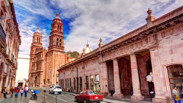
Zacatecas city: UNESCO World Heritage architecture
The state capital showcases one of Mexico’s most cohesive collections of colonial architecture, built primarily from pink cantera stone quarried from nearby hills. The city’s irregular topography, built across several hills and ravines, creates a unique urban landscape of winding streets, hidden plazas, and dramatic vistas that reveal baroque facades and church towers.
Cathedral and baroque masterpieces
Zacatecas Cathedral represents the pinnacle of Mexican baroque architecture, with its elaborately carved facade featuring indigenous and European motifs integrated into complex religious iconography. Construction began in 1729 and continued for decades, allowing craftsmen to develop increasingly sophisticated decorative techniques that influenced church architecture throughout northern Mexico.
The Calderón Theatre, built in the late 19th century, demonstrates the city’s continued prosperity during the Porfiriato period, when mining wealth funded cultural institutions and public works that complemented the colonial architectural heritage.
UNESCO recognition
The historic center received World Heritage designation in 1993, recognizing both its architectural significance and its role in representing the cultural synthesis that occurred during Mexico’s colonial period. The designation encompasses religious buildings, civil architecture, and urban planning that together illustrate how European architectural traditions adapted to Mexican materials, climate, and cultural influences.